Sunday 2nd August saw me driving off to North Devon to park at Hartland village and spend the day walking round the Hartland area of the South West Coast Path as well as finding some green lanes and roads no longer suitable for motor vehicles to connect round in a circular walk to my start point.
I left the village almost immediately following a footpath through some woods and then scrambled through some undergrowth to find the ruined remains of St Leonard’s Chapel. It was certainly a ruined building and with the eye of faith possible to imagine that it had been a small chapel. From there I pushed through brambles and stinging nettles to reach a very narrow road with grass growing in the centre. I followed some quiet lanes while looking at verges resplendent with colourful wild flowers including lots of honeysuckle. Soon I was on a footpath heading to the coast walking above a stream. The stream formed an impressive waterfall as it met the coast at Speke’s Mill Mouth. I’m not sure how, but I managed to miss this dramatic waterfall the first time I walked this part of the coast path – clearly at the start of that day setting out from Hartland Quay I had been racing along too quickly, thinking about the multitude of valleys and cliffs together with the inevitable ascents and descents of the rest of my trek.
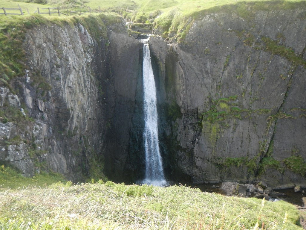
Speke’s Mill Mouth waterfall 
The smaller waterfall (and typical chevron strata) 
Interesting cliffs and beaches
Having ensured that I saw and photographed this now seemingly unmissable feature, I was struck by the unusual rock strata in this part of the coast line. The cliffs feature a folded sequence of shales and sandstones deposited approximately 320 million years ago during the Carboniferous period and then subject to folding due to tectonic plate collision. On the beaches the rocks are eroded into characteristic lines etched out by the forces of the Atlantic waves.
Sheep were grazing on the grassy cliff tops as I walked around the landward side of St Catherine’s Tor to another smaller waterfall. The presence of more people signified that I was reaching Hartland Quay where there is a large car park. I walked out to the viewpoint.
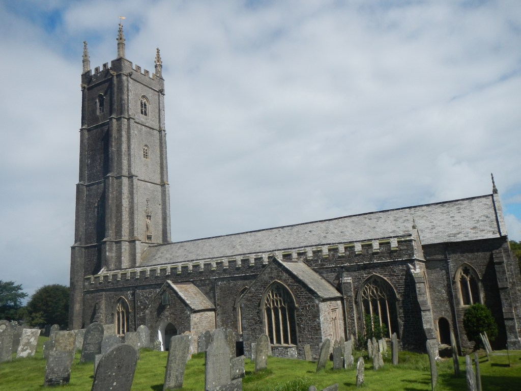
From Hartland Quay, given that I have previously walked the coast path, I turned inland to Stoke to look more closely at the prominent church. This church is the parish church for Hartland despite being some distance from the village and is dedicated to the Celtic St Nectan. It boasts the highest church tower in Devon and was a landmark for sailors in the past. The churchyard contains the grave of Mary Norton, most famously author of “The Borrowers”. However I didn’t find the grave.
From Stoke, I took a minor lane (unsuitable for motor vehicles) which led over an interesting double arched old packhorse bridge from where there were views of Hartland Abbey. I avoided the temptation to take the “private” path to the coast as that was for people who had paid to visit the Abbey grounds. Instead I continued along the quiet lane, before following a narrow path between two high hedges, eventually regaining the coast path just before reaching Hartland Point.
The area of the Point was relatively busy with several families including one with a mother who was educating her son loudly about the history of World War 2. I decided not to detour to the lighthouse, given the impossibility of adequate social distancing. I was soon wandering past the radar station which has an ongoing function in Civil Aviation. However RAF Hartland Point began life in 1941 as a naval VHF intercept station linked to the Enigma (Code Breaking) operation at Bletchley Park. In June 1942 during the 2nd World War it formed part of a comprehensive system of radar detection covering the British coast. Hence I assume the reason for the mother choosing this moment to explain some 20th century history to her son.
The weather was clear and sunny so I had excellent views to Lundy Island and further round the North Devon Coast where I could make out the prominent huge white-painted Saunton Sands Hotel.
My route continued with the sea at varying distances to the left and farmland to the right. There were multiple gates – I’m sure that many of these have replaced stiles. An interpretation board near Windbury Point explained that this had been an Iron Age Hill Fort. I could also see the impressive Blackchurch Rock natural arch and above that one of the several ornamental “shelters” on the Clovelly estate.

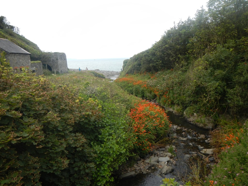
I descended to Mouth Mill beach with its old lime kiln and the stream running steeply down to the sea. The wooden bridge over the stream is relatively recent and I forded the stream last time I walked along there.
My time was fast running out so I decided to cut through the estate to a footpath leading to the National Trust car park at Brownsham. It would have been enjoyable to continue on the coast path as there is always something interesting coming up in a few hundred yards but reality meant that I had to take the decision at some stage to turn towards Hartland. In fact this decision was fortuitous as there was an extremely heavy band of rain which I hadn’t been expecting. I thought it might be a passing squally shower but then had to admit defeat and stop to don full waterproofs and the rucksack cover.
I found myself on another lane which was unsuitable for motor vehicles. Notices on the verge explained that this was a wildlife area and not to be disturbed. Further quiet lanes led back to my car in Hartland. Certainly it’s an interesting area to explore and I could have spent longer looking at many fascinating features – geological, archaeological, historic and botanical.
